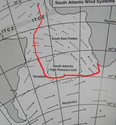
 For those who have been wondering why we have been taking the route that we have, this picture shows the planned route from Cape Verde. The route is long, and indirect, as it is planned around weather systems, not the shortest distance. The idea was to cross the ITCZ (doldrums) where it was relatively narrow, get as far south as possible using the SE Tradewinds, then go south through the Variables, and then go east with the Westerlies.Getting all the south in on the western side of the South Atlantic avoids having to beat directly into the SE Tradewinds on the eastern side of the South Atlantic (which extend further south than on the western side). Avoiding the South Atlantic High was a key point to the route chosen, as inside the high, there is very little wind, so it is much faster (unless you have a lot of fuel to motor with) to sail around the high, where there are much better winds.BTW, my access to this blog while I am at sea is limited to posting updates. I am not able to see comments on the blog until I get to somewhere with an internet cafe. So if you have posted a comment, thanks very much, I will read it after reaching shore. Email to my regular (non-satellite) email address also does not get to me at sea, and will be read ashore.
