Franklin Strait
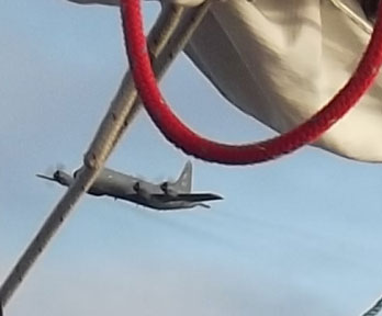 A few days ago, sailing down Franklin Strait, we overheard a call from Canadian Patrol Aircraft 102 to two vessels by name. From the name, I knew one vessel was a sailboat, its name was on the transom, which was vertical, and the letters weren’t all that big, so I thought it would be difficult to read that name from an airplane. I also knew that sailboat had an AIS transmitter (this transmits vessel name, course, speed and position automatically, for collision avoidance), so figured the plane was decoding the AIS transmission–otherwise, they would have called the vessel by position, not by name.About twenty minutes later, I heard a plane. There were enough clouds in the sky that I did not think a plane would see a boat, but within a few seconds, a low-flying plane that looked to be a military Hercules flew by about 100m away (too fast to get a good blog pic). Clearly they had picked us up on radar (we have no AIS transmitter, and the steel deck would make a good radar target). About 30 seconds later, Canadian Patrol Aircraft 102 called us on the VHF by name. I thought they had impressive cameras to be able to take pictures of the boat that were clear enough–at the speed they were going–to be able to read the name on the side of the hull. They said they were on a routine patrol, and wanted to know Vessel Name, Country, Home Port, # of people aboard, Last Port, Next Port and Owners Name. I gave them all the information and they continued on their way.Today, in Victoria Strait (the blog is a bit behind), in somewhat foggy conditions, the same plane announced it was conduting a routine patrol and flew over us. They were farther away this time (a good idea in fog!), and took a few minutes before calling us by our position. We replied, same information as before, and they continued on their way.We have heard nothing else on the VHF since leaving Greenland.
On The Radar
Reply
 Bellot Strait is an 18 mile long passage between Prince Regent Inlet and Peel Sound. It was named after Lieutenant Bellot of the French Navy who came across it in 1852. It has a difficult reputation due to its fast tidal currents and a rock that is awash (so hard to see) near the eastern end of it. While there was no ice when we passed, Bellot Strait has a reputation for quickly jamming with ice. The Sailing Directions note: “The tidal streams run with great strength through Bellot Strait…In the vicinity of Magpie Rock, the currents are highly variable; localised 7-8 knot westerly currents have been reported on the north side of the channel at the same time that equally strong easterly currents were flowing on the south side. Mariners should exercise extreme caution in this area.” There is a range (two markers on shore, if you keep the boat in line with the two markers, you know what course you are on, despite not knowing how the currents are pushing you around) which the Sailing Directions mention as in need of paint in 1977 (no updates since then–this is not a frequently-travelled route). The ranges were visible enough (we had good visibility), and we entered the strait, intending to pass Magpie Rock (the real danger) just before the current turned and started going in our direction (so we would pass slowly, with more control). The chart notes that the current turns there about two hours before High Water at nearby Fort Ross. To figure out when the current would turn (ie, when was High Water at Fort Ross), we had three methods of getting tide information, the Canadian Tide & Current Tables for the Arctic, NOAA’s Tide Tables for East Coast of North & South America, and wxtide32, the free tidal calculation software program. The three methods of determining the tide resulted in three answers, differing by as much as two hours :). We left in time to be early, so no matter which source of tidal information was correct, by slowing down as necessary, we could arrive on time. Of the three methods we used to figure the tides, the free software program came up with what seemed the closest result. —Thanks all for the comments and greetings. I’ve not heard of the Mars on Earth Project (when we get to a town where we can get internet access, I’ll look into it).
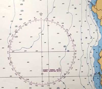 Being close to the magnetic north pole means that magnetic compasses don’t work. The needles try to point down. I’m not sure where the magnetic north pole is now (the magnetic poles move), but it is within several hundred miles of us. Issuma’s compass stopped working in NW Baffin Bay. Nautical charts have compass roses on them, where a compass dial in relation to True North and inside it, a smaller compass dial in relation to Magnetic North. The picture is from a Canadian arctic chart.
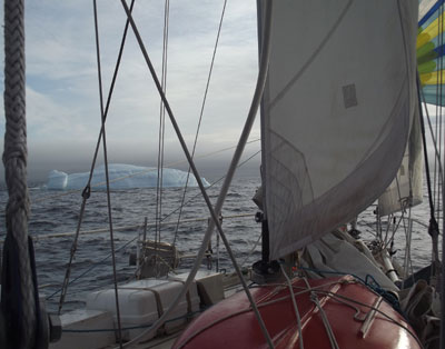 The well-rounded iceberg in the picture looks like it has been floating around for a while, and has turned at least partially over before, based on how rounded it is. Possibly this is a bergy bit, not an iceberg, the difference being a bergy bit (piece of ice broken off an iceberg) shows less than 5m/15′ above the surface of the water. Amos, that is a great poem (in the comments to an earlier post). Thanks for sharing it.
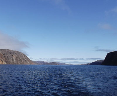
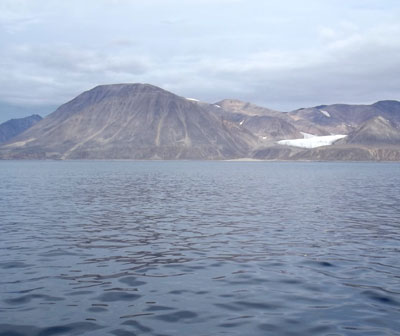 The stark and striking coastline of Devon Island. The blog is a bit behind, we are now in Bellot Strait. To answer George’s questions: We left Upernavik with 1400 litres of fuel, which gives a theoretical range under power (at 4.5 to 5 knots) of 1400 miles. A lot less if in ice. Things are much different now than in Amundsen’s time. Besides having GPS, radar and better charts, there is much less ice now. Getting trapped in the ice is still a great danger, as there is still ice, and even in areas where the new ice has melted, winds can take older ice breaking up in other areas and bring it into areas that would otherwise be clear, but on the whole, the arctic ice is melting. As for seal and bear hunting, we have enough ammo for protection against polar bears, but not really enough for subsistence hunting.
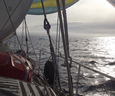 While much of the crossing of Baffin Bay involved motoring in calm, foggy conditions, sometimes there was beautiful sailing across enticing, misty, sunlit seas.
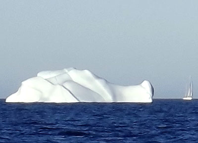 In the middle of Baffin Bay, after a few days of seeing nothing but sky, water, ice and fog, Jordan saw a sailboat in the distance. I called on the VHF radio for sailboat at our approximate position, and Jeffrey Allison of Essamy answered. We had met in Upernavik, as we were both on the same dock. They left a little later than us and followed a different course–going north of the ice in the middle of Baffin Bay (on yesterdays image) instead of south of it like we did. We had a chat and took some pictures, then continued on our separate ways. Thanks all for the comments on the blog. The airtime on the satellite phone has been extended, thanks Timothy. Victor and Peter, thanks for the ice reports. Blair, thanks for the Arctic Bay info. Yvonne, thanks for thinking of us. The sailboat you saw was probably either Matt Rutherford singlehanding a 27 foot sloop, or an Austrian family’s boat. If you’re going to be staying in the Lancaster Sound and Barrow Strait area, we’ll probably miss you, as we have a fair wind and are heading towards Prince Regent Inlet (I’m behind on the blog).
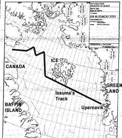 William Baffin was the pilot for Robert Bylot’s 1616 voyage from England, around Kap Farvel (south tip of Greenland), into Davis Strait, up the west coast of Greenland to Melville Bay, then to Smith Sound and Lancaster Sound, then south along the coast of Baffin Island. This was a great achievement for the time (no European had gotten so far beyond Davis Strait), and many doubted that the accounts of the voyage were true. For two centuries afterwards, instead of showing Baffin Bay, charts showed a dotted bulge north of Davis Strait noting the legend of Baffin Bay.The picture is from an Ice Chart, used because it was handy, and already in digital form. I’ll come back to Ice Charts another time. The Ice Chart was received as a weatherfax transmission, hence the grainness and noise in the image. Issuma’s track is roughly shown on the map–we intentionally went south of the ice in the middle of Baffin Bay, and then did some tacking later, as required by the wind at the time. Much time was spent motoring in no wind and dense fog. The arrows on the map roughly show the currents in Baffin Bay (I drew them in, they are not part of the ice chart). If the blog posts stop after this entry, it is due to a problem getting my Iridium satellite phone airtime refilled, complicated by a technical problem with the satellite phone vendor’s telephone system.
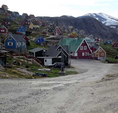 The tidy little community of Upernavik (it means The Spring Place). With a population of about 1100, Upernavik is the largest settlement in the area. The harbor is very open to the NW, but there are other places to anchor around the island of Upernavik to get shelter. We made a very quick food and fuel stop here, we arrived after midnight, tied up to a fishery research boat on the dock, and were gone early in the afternoon. The blog is now a few days behind. Thanks for the comments on the blog. Yes, Iceland is just around the corner from Greenland and it would certainly be a nice place to visit again.