Nunavut
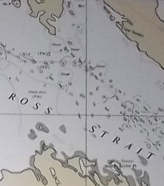 George asked a while back about how we were deciding where to stop. At the time, I was pushing hard to get up the Greenland coast so that if ice forecasts for Canada were good, we would have the opportunity to head towards northern Canada from northern Greenland (there is a warm ocean current going up the west side of Greenland, and a cold current going down the NE side of Canada, so if you want to get to the north of Canada by sailboat, it is best to go there via the west coast of Greenland). So my priorities were to make as few stops as possible in the interests of keeping moving during the short time we had. It was extremely tempting to go into Disko Bay, which is full of icebergs, just to see the spectacle, but we sailed by without stopping because we didn’t have time. When deciding where to stop, we look at things like the expected weather, to see if there will be shelter from it, the possible weather, to see under what conditions we’d need to leave, how complicated the navigation is, can we sail in or do we have to motor, is there likely space to anchor or tie up, if there is a settlement there, what facilities (ie water, fuel, groceries) are there, and what interesting things are there. How complicated the navigation is means things like how many shallow areas/rocks need to be avoided and how difficult are they to identify and avoid and how well are the charts likely to agree with the GPS positions–always something to consider in places not frequently travelled. To give an example of choosing a stop, I really wanted to visit Gjoa Haven. This settlement is named after Roald Amundsen’s Gjoa (the first vessel to go thru the Northwest Passage), which spent two winters in what one of the crew called “the finest little harbor in the world”, so there is a lot of historical interest in going there. There is a community in Gjoa Haven to visit, and we could clear customs, buy fuel (via jerrycans) and food, and have a safe place to leave the boat while we were ashore. Gjoa Haven is also along the best-travelled route through the Northwest Passage, as the shallow waters stop the icebergs, so the waters that need to be sailed to get to Gjoa Haven tend to be free of ice earlier. As we sailed towards Gjoa Haven, a problem became apparant about 100 miles away. The wind was shifting, and it was now dead to windward that we would have to sail for about 50 miles to get through James Ross Strait. The picture shows a portion of the chart for that area. Depths are marked in fathoms (a fathom is six feet), and there are only depths marked in a small area–the rest–white space–has not been surveyed, and is full of unmarked shallow areas. So we were looking at beating dead to windward through a relatively narrow channel. While that alone is not a big problem, the furler for the (yankee) jib had failed, so sailing to windward was more difficult than usual. So we reluctantly bypassed James Ross Strait and our planned stop at Gjoa Haven, and sailed via Victoria Strait instead.
