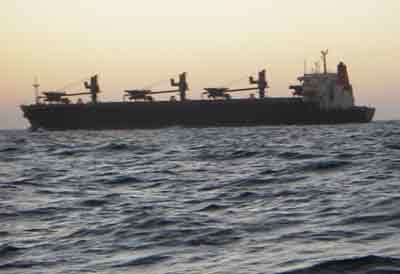
 Along the east coast of Uruguay and southern Brazil there are quite a few ships heading to and from Rio de la Plata. It is really nice having the AIS (Automated Identification System) when traffic is near, as you get a display of the ship’s position, course, speed and name. Knowing the name of the ship makes it much easier to call them on the VHF to confirm which side they are passing or overtaking on if they look to be coming close. I called a Brazilian freighter the other night to confirm how what side they would overtake us on (and to confirm that they had seen Issuma on their radar). The freighter’s crew had already computed our course and speed (their radar likely does most of this for them), and, while overtaking closer than I’d have preferred at 20 knots (a few hundred metres), there was no danger. Clicking on the map on the right side of this page should show the most recently updated position.
